 Time of Run : 8.09 am
Distance : 29.42 km
Time : 2:55:59
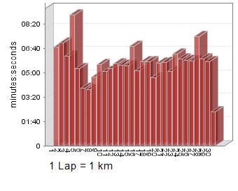
Pace : 5:59 /km
Heart-rate Max : 169
Heart-rate Avg : 141
 Notice the elevation chart, the first 30 minutes was all up hill, rising from sea level to about 310 metres.
No warm up for this run. My heart-rate immediately up there around 160 bpm, obviously the hill causing it.
 Fastest lap (7) 3:58 /km (on the descent)
Slowest lap (4) 9:19 /km (was lost)
Highest Avg HR - Lap (2) 158 bpm
Lowest Avg HR - Lap (9) 126 bpm
Today's run all started yesterday or last night for me. I'm not normally this organised but I made sure my bag was packed, gear to be worn out and ready to be put on in the morning. My homemade energy gel all ready in the fridge. Just had to remember to retrieve it this morning.
Went to bed early, well early for me, about 11 pm. Was up at 4.30 am and as per usual checked my weight at 78.4 kg. I was as quiet as a mouse, don't think I disturbed my other half, she lets me know when I do. Had breaky almost straight away, some cereal, orange juice and a multi-vitamin tablet. Of recent times that's my usual breakfast.
I was out the door at 5.10 am and heading down the road to Cape Schanck.
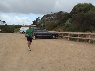
I arrived at the Cape Schanck light-house car park about 7.10 am and heaps of Cool Runners already there.
It was cold and miserable (raining) at this time. A few of the 56 km runners had volunteered to pick up the 28 km runners and get us to the start at Dromana. I hitched a ride with Robert Boyce (cr - rb).
While still at Cape Schanck my run nearly ended before it even started. In my haste to get to the toilet block I locked my keys in the car. Fortunately the door was not fully shut, though it was locked closed. Peter (cr - Pbig) just happened to have a coat-hangar in his car. Well that did the trick. I mentioned to everyone that that didn't need to be mentioned again, oh well, I've mentioned it now.
Robert and I drove to Dromana, the start of the event. Robert was running the 56 km version. Far to far for me.
At the start, Brendan Mason (cr - Virtual Runner), today's organiser, gave all of us maps and instructions for the course. I suppose I should have listened more intently. I was thinking along the lines I'll follow a bunch or someone and therefore getting lost or off-course will not be a problem. How wrong I was.
 Just prior to the start a group photo was taken, about 30 of us. I'll insert the photo here when I get it, most likely from the CR website.
About 8.09 am the event started. I was in there with the first bunch climbing this big bloody hill right from the start. I followed the first bunch and was relying on them to be following the directions. There were tracks that went off in all directions. Well as you can imagine the leading bunch took a wrong turn about 20-30 mins gone and I followed. I'm not blaming the bunch I was following, I'm blaming myself for not reading the directions.
At this point I was running with Lachlan from Maryville and we realised that we'd stuffed up. From the Google Earth map it's quite obvious where we went off course (is highlighted on the chart). That little diversion is 1.5 km and I've estimated that we actually ran further than that as we back-tracked and ran over the same ground a few times. I believe we probably ran about 2 km more than we had to.
When we found the right track again all the others had zipped through and we were into catch-up mode.
This is truly the first trail run I've done. Lachlan was catching up more so than me in that he left me behind. Now I had to read the directions. At certain points I had to stop to study the directions with the features at hand, a little disconcerting at times. Some tracks that I was running along I was thinking surely this can't be right.
At various points my confidence was restored somewhat when I saw runners ahead of me and guessed or assumed that they were tracking along the correct track.
Some of the tracks I negotiated were quite precarious. One was a narrow track at the top of a precipice. This section was towards the end of the run, I believe prior to crossing Boneo Rd. Along this section all it would take is to place your foot in the wrong spot and would be easy to lose balance and fall down the side. Well it didn't happen to me, though I was thinking about it at the time. It went through my head, "What if?"
Other parts were wooden bridges or decking covering the track. Some deckings were covered with chicken wire. Some of the planks had rotted away or about to and the message to self was don't step on those planks. Along one section I missed the chicken wire part and my foot slipped, luckily I kept my balance but it did give me a fright. Lachlan was just ahead of me at this point.
As I approached Boneo Rd Brendan was just ahead and then I knew I had taken the right path. Brendan told me to cross the road and continue on the track. His main advice was to keep the coast on my left. My misses reckons I've got a memory like a sieve and so I was saying to myself numerous times "coast on left, coast on left....".
 Considering the weather was miserable just prior to the start, during the event it was only cool and overcast. It didn't rain, though it wanted to.
After 2:55:59 my Garmin said 29.42 km travelled. Other CR's with Garmins (that didn't go
 off-course) indicated 27.4 km.
Photographs were taken of all the 28 km finishers, I believe, by Brendan's wife. I'll insert those photos when I get them.
No injuries today other than soreness in legs. All afternoon I felt a little (well maybe a lot) drained or energy sapped.
I'll do this again next year or when ever it's organised again.
Stats as of 27 Nov 2005
Weight : 78.4 kg
Last 7 Days : 82.5 km
Last 28 Days : 212.0 km
November 2005 : 206.8 km
YTD : 2086.8 km
Weekly Avg (2005): 43.5 km
Monthly Avg (2005): 189.7 km
Yearly Avg (2001 on): 1484.9 km
Total (2001 on): 7424.3 km

No comments:
Post a Comment